![]()
Feasibility study on applying a spatial footprint approach to quantifying fishing pressure.
The Department for Environment, Food and Rural Affairs (DEFRA) revised policy regarding the approach to the management of commercial fisheries in European Marine Sites (EMS) aims to ensure that all existing and potential commercial fishing operations occurring in EMSs are managed in line with Article 6 of the EU Habitats Directive. This has resulted in the need for the IFCAs (Inshore Fisheries and Conservation Authorities) and the MMO (Marine Management Organisation) (with the assistance of Natural England) to assess the impacts of all fisheries on designated features and habitats within Marine Protected Areas (MPAs) in England and complete these evidence-based assessments, with any respective management in place, by the end of 2016.
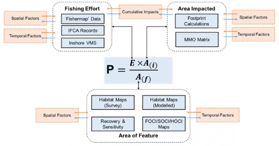
A footprint approach to the quantification of fishing pressure has been proposed as a mechanism to standardise assessments of impacts on designated features and habitats for inshore fisheries. However, knowledge and quantitative data of the spatial distribution of activities in most inshore areas is currently a significant evidence gap for fisheries management.
This study tested the feasibility of the spatial footprint approach and identified the data available for inshore fisheries that will be needed to quantify fishing pressure, i.e. to quantify fishing effort (vessel days) expended within the feature area, the area fished by an individual vessel in one day and the total area of the feature that is being fished (i.e. by an entire fleet).
The footprint approach enabled an estimation of fishing pressure to be developed reasonably simply. However it is suggested that a more sophisticated modelling approach (with a GIS component) would be a better approach to account for the variety of gear, operational parameters and simple geospatial aspects of fishing activity and of the features themselves that have been simplified in the case studies.
Name of Client
MMO
Project Dates
Country
UK